Why the Waikōloa Evacuation Study Doesn't Change the Case for a Second Road
On Tuesday night, Hawaiʻi County Civil Defense and KLD Associates shared the Waikōloa evacuation traffic study results. The meeting happened just four days after a 200-acre fire broke out south of Waikōloa Road and forced a limited evacuation of residents. The timing stood out to everyone.
The main finding of the study was that it would take about four and a half hours to get the last vehicle out of the area.
But instead of suggesting a second exit from the village, the KLD consultant recommended closing Queen Kaʻahumanu Highway during an evacuation, like it does for Ironman events. She said this step alone would save about an hour. In her words, if you stop traffic on Queen K, "you don't need to add another lane."
This assumption is based on a scenario that does not match any wildfire emergency that the Waikōloa Village community has actually experienced.
Residents spoke up at the meeting, and some of our frustrations were reported in the news. One official told the room to calm down.
But we will respond to a flawed study with facts, because the facts support our case.
The key facts, all from inside the report
A Wildfire event was not modeled. None of the widely accepted factors included in Wildfire models - Fire Spread Rate & Direction, Smoke & Visibility Degradation, Embers & Spot Fires, Wind Speed & Direction, Driver Behavior, etc., played any role in the study. There is no closure of Waikoloa Road westbound, or in both directions, which is exactly what Friday's fire threatened. The words "Mana Road," "2021," and "Lahaina" do not appear anywhere. The model was never checked against the two real-world evacuations this community has experienced.
The model used was built for nuclear power plants. KLD's DYNEV-II model was developed for FEMA and validated by the NRC for evacuations around nuclear plants, and the study's methodology follows NRC guidance (NUREG/CR-7002). Those studies assume a radiological plume: a hazard that never blocks a road. The model doesn’t address the Lāhainā-type conditions Waikōloa is exposed to.
Every scenario evacuates the beach resorts simultaneously with the Village. Because they used the wrong model, Waikoloa traffic must compete for access to Queen K with roughly 3,400 resort vehicles and 10,900 pass-through vehicles. That has never happened in any real evacuation here. In reality, the resorts are the refuge.
A no-traffic-control assumption came from the county itself. Assumption 6 says, "Per the County of Hawaii, traffic would not be stopped or diverted at any point." Yet the county runs exactly that control over every Ironman, and ran it during the 2021 evacuation. The study's own Appendix B.4 shows Queen K access control saves a full hour.
The study never tested the second road doing its actual job: being there when Waikoloa Road isn't. Their own Appendix B.1 shows losing Waikoloa Road eastbound costs this community THREE HOURS. A second road is not about saving five minutes on a blue-sky day. It is insurance against the three-hour day, and that is the one scenario the County didn't run.
The second road "penalty" is 10 to 25 minutes, and it is an artifact. KLD modeled the road as a stop sign forced north into an uncontrolled, fully loaded Queen K, not the intersection HDOT actually designed with merging lanes. KLD's team has acknowledged that a proper intersection with traffic control should significantly improve the results.
The model says the longest anyone waits is about an hour. Plenty of us sat in it for 90-plus minutes in 2021, in a smaller Village, and 2021 was a no-notice event, which the study's own appendix shows adds one to two hours to everything.
Future growth counts only Kamakoa Nui. Waikoloa Greens, Nana Kai, and the Lincoln Avenue project appear nowhere: roughly 6,000 future residents are missing. Even so, the study shows evacuation times blowing out as the population grows. The county's own study proves that adding residents without egress capacity is measurably dangerous.
The gaps HPD and the Waikoloa Schools Principal exposed at the meeting on Tuesday night are confirmed in the document. HPD had no role in setting assumptions. The study simply assumes a school bus will arrive within 2 hours and shows 1 bus available against 9 needed, with no source cited.
Problem 1: The model created its own traffic bottleneck.
Here is what the study assumed:
A mid-day, mid-week afternoon, with no fire and no obstructions of any kind
Every road is open in both directions
Waikōloa Resort visitors and residents are evacuating at the same time as the village, both feeding onto Queen K. (Critically, this has never happened and we cannot imagine a scenario when it would. Unless there was a tsunami and a wildfire at the same time?)
Queen K is bearing its normal two-way through traffic, with no traffic control at the highway intersections
If you use those assumptions, you get a predictable result: everything gets stuck on Queen K. When that happens, it doesn’t matter how many roads lead out of the village, because they all end up on the same jammed highway. That is how the model says "you don't need another road." The traffic jam it points out is one it created itself.
Problem 2: That is not how our evacuations actually work.
Waikōloa Village has been evacuated due to fast moving wildfire more than once. Our lived experience tells us that the real events are nothing like the model. Here is what actually happens.
Wildfire pushes village residents makai, toward the resort area. That is what has happened every time Waikōloa Village has been evacuated. The only time the resort area was evacuated was in 2021 during the Mana Road fire when the fire jumped the Queen K near the Mauna Kea Hotel and Mauna Kea Hotel guests were issued an evacuation notice.
A tsunami does the reverse. It pushes resort visitors mauka, toward the village. Village residents do not evacuate at all during a tsunami event. Again, the two populations do not move at the same time. That remains a fictitious scenario.
During the last evacuation, there was traffic control at Queen K. Waikōloa Road traffic was directed south, and Hulu Road traffic was directed north. The highway was managed and did not become jammed.
The study imagined a situation where everyone tries to leave at once without any control, which has never happened here. It used this fake traffic jam to say a second road would not help. That does not match our experience or our real risks. This is why the study's conclusion does not answer the real question we face.
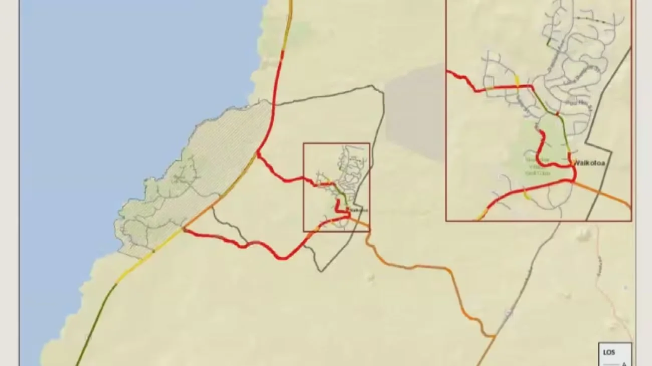
A new study that explores suggestions for expediting emergency evacuations in Waikoloa prompted a spirited discussion. (Hawaii News Now)
Problem 3: The starting data is flawed.
The model assumes Waikōloa Road is open in both directions. But in the last three fires, Waikōloa Road was closed between Paniolo and Highway 190, and Friday's fire started south of that road. Assuming our only paved road stays open both ways is the opposite of what has actually happened.
Terrifyingly, the school plan assumes that 75 percent of Waikōloa students are picked up by family, but that still leaves 177 children who need a bus. There are no buses based in Waikōloa.
The study only looked at one time of day and one day of the week. It did not consider a night evacuation, a weekend, or a fast-moving fire that gives people much less than the four hours the county's own survey says residents need to get ready.
There is a harder question that the study did not ask
If Waikōloa Road is closed in both directions, what evacuation options do we really have? The only other route is a single-lane dirt fire road. This road was built for emergencies, but it is unpaved, narrow, and not meant for steady two-way traffic. In a fast-moving fire, moving hundreds or thousands of people out on this road would be very slow and dangerous. It cannot safely or quickly handle the whole village trying to leave at once, especially if visibility is poor or conditions are stressful. Relying on this dirt road is not a real solution for our community's safety.
Here is what we believe an honest model of a second road would show:
A real second road is not Hulu. And it is not the new Kamakoa Nui emergency road being worked on. It would be a dedicated, paved, two-lane arterial roadway with a capacity similar to Waikōloa Road. If studied honestly, we believe that it would show what the current study leaves out.
A second road would give residents a reliably OPEN exit in an emergency.
Just as importantly, a true second road would give fire crews and first responders another way into the village to fight fast-moving fires. Right now, they have to use the same road that residents would use to evacuate.
Having a second road adds critically needed redundancy. If a fire, a downed pole, or a crash closes one route, the other can still be used. The Friday, July 10, wildfire was another reminder of how quickly Waikōloa Road can be blocked.
A real second road would give the village relief, instead of relying on a dirt road with yield signs that empties onto a highway the study did not manage.
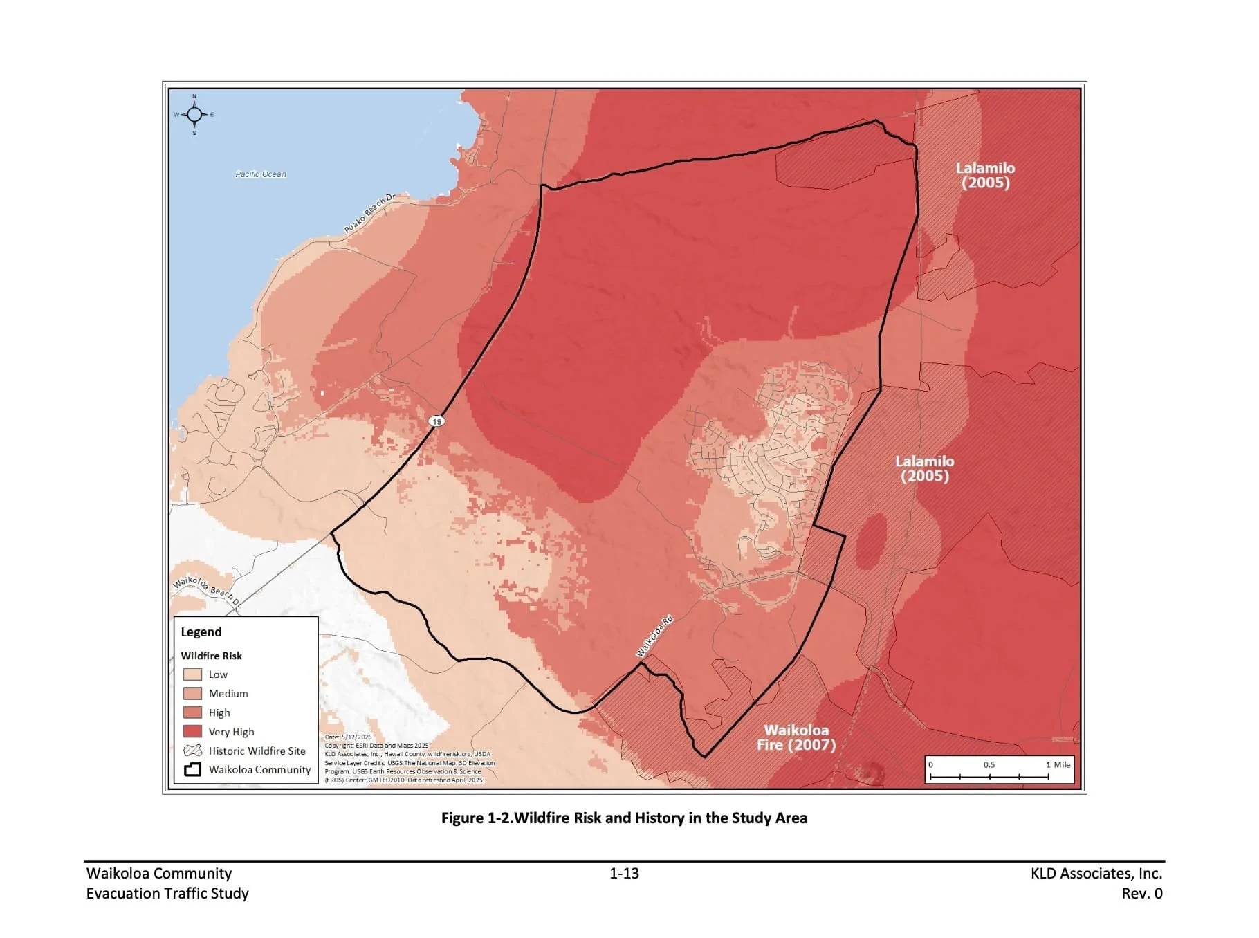
The Bottom line.
The study does not actually find that a second road wouldn't help. It finds that adding one more egress-only connection, in a calm-afternoon scenario with every other road open and Queen K left unmanaged, produces a 10-minute delay, while stating in writing that it never measured the two benefits that are the entire reason this community wants a true second road: emergency-responder access coming in, and redundancy when a route is cut. Meanwhile, the one scenario that matches every fire Waikōloa has actually had is sitting in Appendix B, where clearance time jumps by three hours.
The consultant said that the document is not a decision, but a guide to help the county plan and seek funding.
Hawaii County uses studies like this to justify funding requests and decide which projects move forward. These studies help set priorities toward future infrastructure and are important for grant applications and other funding efforts. When community members share concerns or give input, that feedback can be included in public records, affect planning decisions, and shape the following steps.
A study that models a calm afternoon, keeps our only road open in both directions, and leaves Queen K unmanaged does not capture our real risk. It describes a version of Waikōloa that does not exist when we actually have to evacuate, so it cannot address the need for a second road.
The ask
The report reveals that the Study analyzed the wrong things with the wrong assumptions, which means it gives the wrong answers.
What is needed:
A corrected study, scoped with community review and sign-off.
The fallback, which costs the county almost nothing since KLD's model is already built, is to run the missing scenarios.
The second road with HDOT's designed intersection and traffic control, while Waikoloa Road is compromised
A Village-only evacuation matching 2021 conditions to validate the model. If they refuse a marginal-cost model run after a two-year study, that refusal becomes the story.
We are not asking anyone to ignore the engineering. We are asking that the engineering reflect our lived experience. Model a real fire instead of a calm Tuesday, including the road closures that happen. Add traffic control at Queen K, because that is what we do in real situations. If you do that, the value of a second road becomes clear.
We will keep working on this. Mahalo for reading and staying with us. If you want to get involved, please join us at upcoming meetings, sign up for updates, or contact our group with your questions and ideas. The more voices we have, the stronger our community will be.
Wildfire Safety Advocates of Waikōloa